Menu

Limi Valley Trek – 21 Days

21 Days

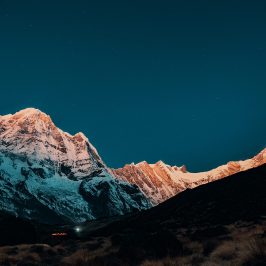
Limi Valley Trek takes you across high mystical and isolated Himalayan terrain, which indeed is a culturally intensive trekking adventure that reveals the unseen side of northern Nepal.

The Limi valley trek 21-day journey explores the nomadic and authentic culture of rural communities that have gone under the radar for generations. In the dry and harsh terrains of Limi villages, Tibetan culture and lifestyle are intertwined, along with the exotic flora and fauna, the majesty of Nepal’s and Tibet’s high Himalayas is on display.

Overview

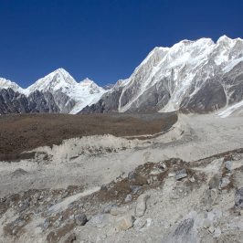
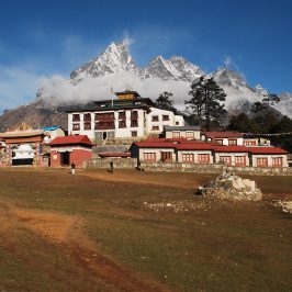
To reach Nepal’s northwestern region, fly from Kathmandu to Nepalgunj and then on to Simikot, Humla. On the fifth day, you’ll begin your trek with an easy hike towards Dharapori. Follow the Karnali river trail until you reach Kermi, a settlement primarily inhabited by the Buddhist community. As you approach Yalbang, the trail becomes increasingly secluded. The trek continues beside the Karnali River, passing past Muchu village and towards Tumkot village. If schedule allows, you can explore the area’s significant Gompas and Dzongs after that continue to Yari or Thado Dhunga, passing through a small Pani Palwang village on the path. Hilsa, Humla’s first thriving town, is reached on the tenth day of the journey.

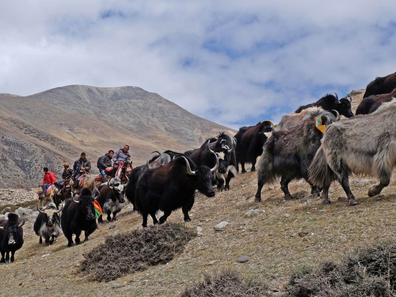
As you go farther north, you will have opportunity to see wild animals on route towards next destination in Manipeme. From here, you enter the Limi valley and make your way to the region’s smallest settlement, Til. Following your exploration of Til, you will continue to the next town, Halji, which is the largest in the area, continue your trek towards Jang, Limi’s third settlement, to reach Chagzur Hot Spring, after a hot bath, proceed to Nyalu Base Camp via Nyalu Pass, through the remnants of the old Limi village route to Sheng Jungma. Stunning sights of Nepalese and Tibetan mountains on route to Ding village herd and can see the magnificent Zhetse valley. The incredible adventure comes to a close as you continue to Simikot, then fly back to Nepalgunj and Kathmandu.

Meals and Drinking Water:

In popular trekking areas like Annapurna, Everest, Langtang, and Manaslu have a menu system with different ethnic cuisines foods as well as western meals, but some places provide you typical Nepali meals which are different from international meals, these meals are prepared by the local supplement, every tourist lodge and tea house has a well-trained cook basically attention to clean, hygienic, fresh, and delicious foods, every lodge has safe drinking water or mineral water. If you buy a water purification tablet from Kathmandu you can take water from the tap and purify it by yourself, this will be cheaper and control plastic pollution as well.

Travel Insurance:

All clients participating in any activity must have travel insurance. Personal injury, death, hospital expenditures, repatriation fees, helicopter rescue, and any other disease covered by the insurance plan will be given. We highly advise you to acquire a comprehensive insurance plan from a trustworthy insurance company.

Passport and Visa

Every client must have a valid passport from the return date with a 6 months prior validity by the Nepalese consulate in your country or immigration office at Tribhuvan International Airport in Kathmandu.

Equipment lists 

  • Find the guidelines regarding essential trekking gears.
  • Daypack above 40 liters. (Must be waterproof)
  • Down jacket (rental available)
  • Warm sleeping bag (rental available)
  • Sun head, gulf cap, sunglasses, headlamp, and torchlight.
  • Ear-muffs, sun Lotions/sun cream.
  • One pair of liner gloves is thin wool and synthetic.
  • Cotton t-shirts, Synthetic t-shirt.
  • Two Long sleeve polyester or synthetic lightweight for sunny days.
  • One Soft-shell jacket water & wind resist.
  • One swimming dress.
  • Inner cloths as your requirement.
  • Liner socks, woolen socks.
  • Proper trekking shoes.
  • Imodium or Pepto Bismo capsules for upset stomach or diarrhea.
  • Diamox for altitude sickness. The guide will help you to take it.
  • One small personal-sized first-aid kit with blister treatments such as moleskin, bands, anti-infection ointments, muscle relief ointments.

Itinerary

The flight into Kathmandu Valley is breathtaking with a panoramic view of the Himalayan ranges and the valley below. A representative will meet you at Tribhuvan International Airport and drive you to your accommodation.

Tour the world heritage sites of Durbar Square, Pashupatinath Temple, Swayambhunath Stupa, and Bouddhanath Stupa. The Durbar Square provides insight into the perceptions of ancient royals. For all Hindus, Pashupatinath Temple is one of the most important pilgrimage sites. The Monkey Temple is also known as Swayambhunath, and the Bouddhanath Stupa is one of the world's biggest stupas. Later in the evening meet up with your trekking guide and prepare for your trek.

Today you'll leave Kathmandu and fly to Nepalgunj. Once you land at Mahendra Airport in Nepalgunj, you will experience a temperature difference. Nepalgunj is the financial hub in the Terai flatlands, bordering India. On the route, you'll pass through several historic settlements. In the evening, you may walk through the streets and enjoy some local cuisine.

After breakfast, you will travel to the domestic airport early morning to catch a flight to Simikot, the administrative center of the Humla region in the north. Humla is rural and isolated from the rest of Nepal, hence the landscape changes drastically. Due to the airport, Simikot is one of Humla's larger and most dynamic settlements, beyond the settlement, you can see the Karnali River, which is also the starting point for an expedition to Mt. Kailash and Western Tibet. The hamlet is inhabited by Tibetan Buddhists, Thakuri, and Khas communities, who are all extraordinarily kind and hospitable. In the afternoon, you may go about the hamlet and visit local sacred places. The most notable attraction is the Bon Shaman Monastery, which was rebuilt after being destroyed.

The first day of your trek starts with a moderate ascent of approximately an hour from Simikot to Dharapori, you'll then descend alongside the Karnali River after crossing a 3,000m/9,842ft traveling through pine forests and settlements. Dharapori will be reached after a steep climb. Along the route, you'll see residents hauling logs of timber and everyday necessities up the steep trail. Dharapori is a tiny rural community populated primarily by Hindus and Buddhists. On this day, you will be camping along the Karnali riverbed.

After breakfast, you will ascend the route that follows the Karnali River along some steep slopes, then, make a rapid descent to the barley, buckwheat, rice, and potato patches and you'll eventually arrive at Kermi, you may explore the village since you have the entire day to yourself. Kermi is the first settlement that is entirely inhabited by Buddhists. In the afternoon, you may visit the ancient Kermi Laikyo Gompa and Lhundrup Choeling Gompa, which are 45 and 30 minutes away from the campground, respectively.

Today's trial is relatively flat with a slight uphill portion, the trail will continue for yet another two hours until it reaches a small pass with barley and buckwheat farmlands, from here descend for around 20 minutes before crossing a large iron suspension bridge over the Sali River. On the path above the gushing Karnali walk through spectacular pine forests, you'll come across villagers from Simkot and Nyinba regions traveling with their mule's caravans along the trail. They trade in Taklakot, which is located on the Tibetan side of the border, after a few more hours on the trail, you'll arrive in Yalbang, a charming and secluded settlement. You may explore the Namkha Khyung Dzong Monastery, which is the largest in the region, after setting up everything for the night. Since it accommodates 130 monks, it is always congested a school and a clinic are also located on the premises of the monastery, you can even attend their afternoon prayers.

Above the Karnali River, the trail from Yalbang to Tumkot starts, pass Yangar village thereafter by crossing a level of terrain with only a few uphill and downhill twists, huge carved rocks can be seen along the way, and the enormous pine trees that give way to tiny bushes further ahead will astound you, a wooden suspension bridge spanning the Karnali river leads to an incredible high-altitude trek on the upper side of the Karnali valley. The ancient salt trade from Humla to Tibet is still going strong, as seen by herds of sheep and their owner's running back and forth along the road, then you'll arrive at Muchu village, which is not far from Tumkot, you can take a break and visit Muchu village. As you approach Tumkot village, continue on the route to locate some modest teahouses. Our day's camp is along the Tumkot River, approximately 20 minutes from the settlement. The village is inhabited by Tibetan Buddhists and ethnic Shakyas, you may visit the Dhungkar Choezom Monastery, Humla's only Shakya Monastery, after setting up camp. It has historically and culturally significant to the residents of the area.

On your route to Thado Dhunga, you'll be trekking in a wild, rugged, and rocky terrain today. The trek begins with a gradual climb up a steep trail which becomes more challenging as you leave Tumkot. Between these, there are no signs of habitation, and only a few sparse juniper trees, pass through Pani Palwang, a little settlement with a few teahouses where you may pause for a break. After the break, continue for an additional 1 to 2 hours of walking, you may either stay in Yari or keep on walking to Thado Dhunga. It is advisable to reach Thado Dhunga so that you can exercise ahead of schedule tomorrow.

Today, you'll go to Hilsa, which is on the Tibetan border, as the environment gets barren, trees seem to fade away gradually, you could see caravans of yaks traveling along and far out in the distance, making makes for an incredible photography sight and come across various tent motel that provides food and drink. The trek will be challenging due to the fact that you will be traversing a high pass above 4000 meters. Start as early as possible to avoid the high winds at the pass, cross more rugged and desolate terrain before beginning the difficult ascent to the 4620m Nara La pass. If there is snow, the ascent becomes much more challenging, Tibetan prayer flags flutter in the wind as you walk through the pass. The view is well worth the effort of hiking to the top and the trail gets relatively gentle after reaching the pass, landscape is as barren as a desert, with just a few vegetation visible in the distance. The Rocky Mountains are ash-colored, copper-colored, brown-colored, and dark yellow in hue. Furthermore, you will be at Hilsa in a few hours. Hilsa is a bustling, lively town in the Humla region. It is primarily populated by Tibetan Buddhists. Other travelers, especially from the Bon, Buddhist, Hindu, and Jain communities, will be encountered along the journey on their way to Lake Mansarovar and Mount Kailash for pilgrimage.

Following the Karnali River, cross the suspension bridge, then continue north towards Limi Valley after breakfast. Snow Leopards, Himalayan Blue Sheep, and Bharals may be seen along the journey if you're lucky, you'll arrive at Manipeme in around 5 to 6 hours, where you'll set up camp for the day. The name Manipeme originates from the carvings of the Mani Mantra on enormous rocks.

You'll be trekking deeper into the Limi valley today, so it'll be a lengthier walk than usual, pack up and cross the Chenglungma caravan camp after breakfast. From there, you'll travel to Cha-Sa Nam-Ka Dzong, a historically significant cave. It is a stunning tourist destination since it is situated on a rocky cliff on a hillside, from here on forth, the landscape is arid, steep, and rocky. To add to the difficulty, you will have to share the steep trail with animals such as sheep and yaks carrying big weights. Limi valley also referred to as Limi village, is made up of three villages: Til, Halji, and Jang. The journey will explore the three settlements over the next few days. At an elevation of 4300 meters, you will first cross Lamka-La, a high pass. Til is the first settlement you'll come upon, despite the arid terrain, it is an agricultural community, and inhabitants cultivate barley in their fields on the western end Willow and birch trees can also be found. It's also the smallest and most accessible settlement on the Tibetan border, when you get to Til, you can rest for a while before exploring the settlement. In addition, the Kunzum Do Nag Monastery, which is said to be 300 years old, can be visited, in what is regarded as the second dispersion of Buddhism in Tibet, you can observe a massive cultural interchange. Interact with the inhabitants who reside in stone cottages and are warm and welcoming. Til village is where you will spend the night.

On your way to Chagzur Hot Springs, you'll travel through Limi's second settlement, Halji, start walking down the route for roughly an hour until you reach Tiljung. Then, following the Tagtsi Khola, the primary tributary of Karnali, from Jang to Til, proceed below, you'll eventually come to a narrow valley to the east, cross another bridge and turn left from there. Finally, you will arrive in the northeast settlement of Halji in about an hour. The largest village in Limi Valley is Halji, a massive gate that will welcome you into the settlement. A Chorten and a huge Mani wall with stone carvings of holy mantras and drawings of Buddhist deities can be found on the side. This village is yours to explore at your leisure, more significantly, you must pay a visit to the magnificent Rinchhen Ling Gompa Monastery, which is over 800 years old. It is the religious hub of the region and belongs to the Kagyu Pa lineage, you can continue walking towards Jang village after exploring the region. Another significant monastery, estimated to be 250 years old, maybe found there. Take a short stroll from there to the Chagzur Hot Spring, where you'll spend the night.

After a rigorous trek, you'll have your first rest day in Chagzue Hot Spring on this day. It's also known as Tashi Tang, which is more well-known in the area you may sleep in today, wash your clothes if you have any, and have breakfast, you have the entire day free today, so you may take a relaxing dip at Chagzur's natural hot springs. The hot spring is renowned for naturally healing any condition. Alternatively, you may hike up to Lapcha Syar, which is 4900m/16000ft above sea level.

You'll leave early this morning for the Jade or Nyalu Base Camps. On the way, you'll make a quick stop at Tulgling. Tugling is a small settlement that has only recently been established, then you have two options for getting to Nyalu Base Camp, you may either take a faster path across a river to the new road or take the longer, more scenic route via Tagtsi. Tagtsi is an old caravan route that connects the Humla Mansarovar and Humla Limi valley routes, the ruins of the historic Limi settlement of Tshamdo/Zambuk/Lama Palya will be seen, next cross the Nyingchhu River and arrive at Tshogo Lake, beyond that are the Talung meadows, where yaks and livestock from the Limi valley graze undisturbed. The day's hard adventure comes to a close here at Nyalu Base Camp.

The trek to Sheng Jungma today is a lengthy one that might take up to 8 hours. The first few hours of the hike will be spent ascending steeply to the summit of Nyalu Pass, which sits at an elevation of 4,990m/14,000ft. It's a difficult climb, but once you get there, the panoramas make it all worthwhile. High-standing Nepalese and Tibetan mountains such as Mt. Kailash, Kanjiroba, Mt. Api, and Mt. Saipal can be seen from here. After soaking in the breathtaking views, descend from the pass to see still another magnificent sight: Sheliman Lake, a tiny lake at an elevation of 2570m/15000ft. From there, you'll continue down to Tshongsa's meadows and river. The sights of the rhododendron woodland will greet you in the spring. Another noteworthy sight along the walk is the Tshogsi Tsan waterfall, also known locally as the wild monster of Tshongsa, which cascades between cliffs. The pasturelands of Sheng Jungma, an hour away, maybe seen far beyond.

Starting from the Tshongsa River, make your way to the left bank of the Zhestse River, which runs east-west, you'll start climbing higher from there until you reach the right bank of the Zhetse, you may stop by the herders' summer camp in Chyadok hamlet just before crossing a bridge. The valley of Zhetse may be seen in its entirety from here. For the night, you may stay at the Dinga Village herder's encampment, you'll have a few hours remaining in the day, so go for a walk around the neighborhood and take some unforgettable photos.

Today's hike starts with a gradual ascent to Langdogd Pass, which peaks at 4,550m/14,900ft and gives gorgeous views of the valley's high cliffs and mountains. After taking in the vistas, descend steeply through a juniper and birch woodland. Takhor Khola is reached by following the path, after approximately 1.5 hours, you'll cross a creek and arrive at Lekh Dinga, a Laga Dinga campsite. The Limi people come here in the autumn for trading and the Laga Dinga people come here for settlement in the summer.

On this day, you will depart Limi Valley and the neighboring districts and go to Simikot, the capital of Humla, begin your hike early in the morning, after breakfast. The settlements of Yapka and Tangin will be on your left throughout the first part of the trip, while Aul Dinga will be on your right, falling steeply towards the Yapka Khola after past them. As you get closer, cross the wooden bridge and rise to Okhreni, a Thakuri village, after taking a break there, you'll continue to Simikot on the freshly built road. The Nyinba Valley will become more visible as you continue walking, you can rest when you get to Simikot. Later in the evening, you and your team can have a local drink with the locals. On this day, your incredible trip to Humla comes to an end.

Finally, your trip to Limi Valley comes to an end after the long trekking days, you'll go to Simikot's domestic airport and then fly back to Nepalgunj, take a flight from Nepalgunj to Kathmandu city. Depending on your flight itinerary, you may be able to do some last-minute souvenir shopping and eat lunch once you get in the city.

Three hours before your flight's departure, our representative will drop you off at the airport. Please do let us know if you want to experience more of Nepal. Choose from one of our pre-planned itineraries or let us create a journey just for you. Note: All of the above-mentioned trekking hours and distances are estimations and should only be used as a general guideline.

Includes/Excludes

Cost Includes

  • All Private Transportation Including Airport Transfers
  • Meals (breakfast, dinner, and supper) during the trek.
  • Insurance for the guide
  • All necessary papers permit and TIMS card
  • A basic first aid box
  • Emergency rescue operation (only if you have Travel Insurance)
  • All government, Local taxes, and official Expenses
  • Farewell dinner at a typical Nepalese restaurant with cultural shows.

Cost Excludes

  • Nepal entry visa fees, you can easily issue the visa on arrival at Tribhuvan International Airport, Kathmandu.
  • Foods and hotels before and after the trek.
  • All kinds of beverages including tea, water, wine, etc.
  • Additional cost by out of management control due to the natural calamities, weather conditions, etc.
  • Personal expenses such as snacks, laundry, telephone, WIFI, hot shower at tea houses on a trek.
  • Personal trekking equipment for this trek.
  • Tipping for the guide and staff (Recommended)
  • Any other expenses that are not mentioned in the Price Include section of this trek.

You can send your enquiry via the form below.

Limi Valley Trek – 21 Days
From $3,900
/ Adult
From $3,900
/ Child
  • Best Price Guaranteed
  • No Booking Fees
  • Professional Local Guide